
Cypress Environment & Infrastructure has an office in Mobile, and this page is our Alabama reference for the full wetland sequence: field delineation, the U.S. Army Corps of Engineers (USACE) jurisdictional determination (JD), and the federal and state permits. It focuses on what differs here: the split between the Mobile and Nashville Districts, the two regional supplements on either side of the Fall Line, the Alabama Department of Environmental Management (ADEM) coastal rules in Mobile and Baldwin Counties, and the Mobile District’s stream mitigation SOP.
Background topics have their own pages: how a wetland delineation works, approved and preliminary JDs, the Section 404 permit, and the broader list of environmental permits.
Which Corps District Reviews an Alabama Site
Alabama is divided between two Corps districts along the divide between the Tennessee River and the rivers that drain to the Gulf. From the USACE Regulatory Areas of Responsibility GIS data, overlaid on county lines:
- Mobile District (SAM): about 87 percent of the state. That is every basin that drains to Mobile Bay (the Tombigbee, Black Warrior, Cahaba, Alabama, Coosa, Tallapoosa, and the Mobile-Tensaw Delta) plus the Chattahoochee, Choctawhatchee, Conecuh-Escambia, Perdido, and other coastal drainages.
- Nashville District (LRN): about 13 percent, the Tennessee River drainage of north Alabama. That covers all of Lauderdale, Colbert, Limestone, Madison, Jackson, and Morgan Counties, most of Lawrence, Franklin, Marshall, and DeKalb, and narrow strips of Blount, Cullman, Etowah, Marion, and Winston.
ADEM’s Section 401 program draws the same line. Because it follows a ridge, a large tract in Marshall, DeKalb, or Lawrence County can drain to both. Confirm the parcel on the Mobile District or Nashville District regulatory pages before filing. Tennessee Valley sites can also need a Tennessee Valley Authority (TVA) Section 26a permit (below).
Wetland Delineation in Alabama
The standard is the 1987 Corps Manual as modified by a regional supplement, and Alabama spans two. South of the Fall Line, which crosses the state from the Phenix City area west through Tuscaloosa, the Atlantic and Gulf Coastal Plain Regional Supplement (Version 2.0, ERDC/EL TR-10-20, 2010) applies: the Inner Coastal Plain (LRR P), which includes the Black Belt (MLRA 135A), and the Outer Coastal Plain (LRR T) near the coast. North of it, the Eastern Mountains and Piedmont Regional Supplement (Version 2.0, ERDC/EL TR-12-9, 2012) applies to the Piedmont (MLRA 136), the Ridge and Valley, the Cumberland Plateau, and the Tennessee Valley (LRR N). The two use different data forms and partly different indicators, so we settle the supplement before fieldwork and confirm it with the district near the boundary.
Conditions that drive most boundary calls in Alabama:
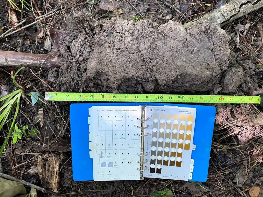
- Black Belt clays. Shrink-swell clays (Vertisols) over chalk and marl have thick dark surfaces that hide redoximorphic features. The Coastal Plain supplement allows indicator F18 (Reduced Vertic: a positive alpha, alpha-dipyridyl reaction for at least 7 continuous and 28 cumulative days) as a problem-soil approach where Vertisols occur, and notes that ponded depressions perched on clay can lack hydric soil indicators. Close calls may need a wet-season visit or monitoring.
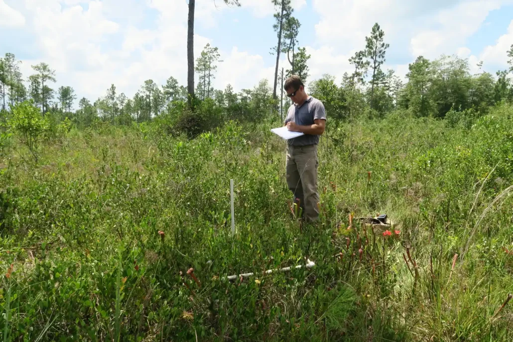
- Wet pine savannas, pitcher plant bogs, and flatwoods. Near the coast, fire-maintained savannas and flatwood depressions can dry out completely in late spring and summer, when FACU annuals can dominate, so soils and hydrology often carry more of the decision than the plant list.
- Bedded pine plantations. Bedding reshapes surface hydrology and soils. The supplement’s Chapter 5 procedures for agricultural and silvicultural lands apply, and boundaries are drawn on what the site would show under normal circumstances.
- River floodplains. The supplement names the Mobile and Tennessee Rivers among the floodplains where indicator F12 (Iron-Manganese Masses) occurs, and F19 (Piedmont Floodplain Soils) serves as a problem-soil indicator where floodplains receive Piedmont sediment.
- Tidal edges in the coastal area. The Corps’ Section 10 limit in tidal waters is the mean high water line, and ADCNR’s submerged-lands rule positions new bulkheads at or landward of the mean high tide line. The report should address each line the reviewing agencies need.
- Tennessee Valley and plateau uplands. Karst sinkholes, spring runs, escarpment seeps, and steep headwater channels are the common problems. Whether each channel is ephemeral, intermittent, or perennial drives both jurisdiction and stream mitigation.
Our Delineation Process
- Desktop review. NWI maps, aerial imagery, FEMA flood zones, soil surveys, and topographic data, plus the Corps district, the regional supplement that applies, and whether the site lies seaward of the 10-foot contour in Mobile or Baldwin County, so the permit path is known before fieldwork.
- Field investigation. Paired upland and wetland sample points at each boundary document plants, soil profiles, and hydrology indicators on the data form for the applicable supplement.
- GPS mapping and flagging. We flag the wetland boundary in the field and map it with high-accuracy GPS, giving the design team and the agencies one spatial reference.
- Delineation report. Boundary maps, data forms, photographs, and field notes, formatted for the Mobile or Nashville District, with streams classified as ephemeral, intermittent, or perennial. For larger developments in the coastal area, ADEM’s application requires the delineated wetlands on a survey by an Alabama-licensed land surveyor, so we coordinate the handoff.
- Corps coordination. On request, we submit the report to the district for a JD or attach it to the permit application.
Jurisdictional Determinations in the Mobile and Nashville Districts
The JD decides which of the mapped features the Corps regulates. An approved JD (AJD) gives a binding answer, normally good for five years (RGL 05-02), and can be appealed. A preliminary JD (PJD) assumes jurisdiction to move a permit forward; it is advisory, cannot be appealed (33 CFR 331.2), and cannot take a feature out of federal review. The Mobile District uses separate request forms for the two. Turnaround is not published; PJDs generally come back much sooner. More on our JD page.
The rule in force. Alabama is one of the 24 states where a federal court in North Dakota preliminarily enjoined the January 2023 rule on April 12, 2023, in a challenge Alabama joined. Jurisdiction here is decided under the pre-2015 regulations as narrowed by Sackett v. EPA (2023), not under the 2023 rule or its September 2023 amendments (EPA status page). A wetland qualifies only where it abuts a relatively permanent jurisdictional water with a continuous surface connection, which the agencies’ March 2025 guidance reads narrowly. EPA and the Army proposed a new definition on November 20, 2025 and supplemented it on September 9, 2026; it is not final. Our Sackett page has the background.
In practice. Flatwood, prairie, and sinkhole depressions separated from streams by upland, and ephemeral channels, are the features most likely to be found non-jurisdictional. An AJD is often worth requesting where that finding would change the site plan. In the coastal area, a non-jurisdictional finding does not end state review: ADEM’s coastal rules define wetlands by the Corps delineation manual, not by federal jurisdiction, and allow filling of non-adjacent wetlands only where no feasible alternative avoids them and ADEM finds they have limited functional value (ADEM Admin. Code r. 335-8-2-.02(3)). Inland, state wetland review generally comes through ADEM Section 401 certification, which attaches only when a federal permit is required. Local floodplain and construction stormwater rules apply either way. See isolated wetlands.
Permits: Federal, State, and Coastal
Corps authorization
Small fills are usually authorized under a nationwide permit (NWP). The current NWPs were issued on January 8, 2026 (91 FR 768) and run from March 15, 2026 to March 15, 2031. According to the Mobile District’s February 13, 2026 public notice, the district added no regional conditions, ADEM issued conditioned water quality certifications for all NWPs on December 4, 2025, and ADEM issued its coastal zone consistency decisions on September 8, 2025. ADEM denied coastal consistency for NWPs 10, 21, 24, 29, 30, 34, 39, 40, 41, 42, 43, 44, 49, 50, 51, 52, 55, 59, and 60(A), so those activities are not authorized by NWP inside the Alabama coastal area and need individual review. The list includes residential (NWP 29) and commercial and institutional (NWP 39) developments. The Nashville District posts its own Alabama notice for the 2026 NWPs; read it for Tennessee Valley sites. Larger projects need an individual permit with public notice, and work in navigable waters also needs Section 10 authorization.
ADEM Section 401 water quality certification
ADEM is the statewide Section 401 certifying agency for permits from both Corps districts. ADEM certifies NWPs and general permits as a group, so an applicant using one generally does not deal with ADEM separately unless contacted. An individual permit needs an individual certification: the Corps issues a joint Corps-ADEM public notice, which serves as the certification request, and ADEM then asks for its fee and any technical information. Certifications are generally limited to five years. ADEM’s Mobile Branch handles certifications in Mobile, Baldwin, and Washington Counties. EPA proposed revisions to the federal certification rule (40 CFR Part 121) on January 15, 2026, so check the rule in effect when you file.
Alabama coastal area (Mobile and Baldwin Counties)
The Alabama Coastal Area Management Program (ACAMP) is managed by the Alabama Department of Conservation and Natural Resources (ADCNR) State Lands Division, Coastal Section, while ADEM handles permitting, monitoring, and enforcement under ADEM Admin. Code Division 8 (chapters 335-8-1 and 335-8-2). The coastal area is the land and water seaward of the continuous 10-foot contour in Mobile and Baldwin Counties, out to the limit of the territorial sea. Large parts of both counties lie landward of it.
- With a federal permit. A Corps permit for work affecting the coastal area needs ADEM’s coastal consistency decision (r. 335-8-1-.09, under 15 CFR Part 930, Subpart D).
- Without one. New commercial and residential developments larger than five acres, wholly or partly in the coastal area, that contain areas which are or could be delineated as wetlands, adjoin coastal waters, or are crossed by the coastal construction control line need an ADEM permit. The application includes a survey by an Alabama-licensed land surveyor showing the delineated wetlands (r. 335-8-2-.11).
- Mitigation plans. Where ADEM requires mitigation, the plan covers a survey of the mitigation site, planting and elevations, legal protection of the site, and five years of monitoring (r. 335-8-2-.03). See our coastal consistency page and 401 and coastal permit overview.
Other state and federal reviews
- State-owned submerged lands. Structures on or work in state water bottoms start with an ADCNR State Lands Division Request to Impact application ($100). Small single-family piers and docks with less than 5,000 square feet of preempted area can receive a Consent of Use; larger or revenue-generating structures need a riparian easement; removing bottom material needs a dredge permit (Ala. Admin. Code r. 220-4-.09). See dock and pier permitting.
- TVA Section 26a. In the Tennessee Valley, TVA approval is required before building any obstruction affecting navigation, flood control, or public lands along or in the Tennessee River or its tributaries, including fills, culverts, bridges, and shoreline stabilization (18 CFR Part 1304). TVA will not issue a 26a permit until the Section 401 certification is obtained or waived (18 CFR 1304.2(d)). On TVA reservoirs such as Guntersville, Wheeler, and Wilson, the Nashville District’s 23-PGP-01 (through August 13, 2028) authorizes listed minor activities once TVA issues its 26a permit.
- Listed species. The gopher tortoise is federally threatened west of the Mobile and Tombigbee Rivers; east of them, the U.S. Fish and Wildlife Service found in 2022 that listing was not warranted. Alabama’s streams, particularly in the Mobile River Basin and Tennessee River tributaries, carry many federally listed mussels, snails, and fishes, which can bring surveys to stream crossings. A Corps permit brings ESA Section 7 consultation into the schedule. Our gopher tortoise survey page covers survey scope.
Compensatory Mitigation, Including Streams
- Mobile District, streams. Stream debits and credits are calculated with the district’s 2012 Compensatory Stream Mitigation Standard Operating Procedures and Guidelines (SAM-2011-317-MBM). The impact worksheet scores stream type, priority area, channel condition, impact duration, dominant impact, and a length-based scaling factor; credits come from in-stream and riparian buffer worksheets. Primary priority areas include waters with listed species, outstanding national or state resource waters, essential fish habitat, and shellfish grounds, so check ADEM’s use classifications (ADEM Admin. Code ch. 335-6-11) and the species record for the reach. Final designs are expected to follow natural channel design based on a reference reach, and riparian buffer preservation can supply no more than 30 percent of a plan’s credits. After Sackett, the SOP applies only to streams that remain jurisdictional.
- Mobile District, wetlands. The district’s mitigation page posts its wetland tools, including the Wetland Rapid Assessment Procedure (WRAP) and the Proximity Factor Method, which sets the added compensation when credits come from a bank outside the impact’s 8-digit watershed service area.
- Nashville District. North Alabama sites do not use the Mobile SOP. In Tennessee, the Nashville District uses the Tennessee Stream Quantification Tool and Debit Tool; confirm the method it applies to Alabama sites at the pre-application meeting before you price stream mitigation. Alabama banks in its area currently list stream credits as ratio credits.
- ADEM coastal mitigation. In the coastal area, ADEM approves its own mitigation plan, and the rule text calls for creation of wetlands or restoration and enhancement of degraded wetlands rather than preservation (r. 335-8-2-.03).
Bank credit availability by service area is posted in RIBITS. Related pages: mitigation banking, how stream mitigation works, and buying credits or establishing your own bank.
Cypress in Alabama
We are licensed in Alabama and work Alabama sites from our Mobile office. For CN (Canadian National), we completed a roughly 200-mile linear corridor delineation from Mobile, Alabama to Jackson, Mississippi that crossed both states, along with endangered species surveys, stream characterization, an environmental assessment, and permitting; the Alabama segment was Mobile District work (see our Mississippi page). In the Mobile District we also completed the delineations and bank documents for the Little Biloxi River, Lower Devil’s Swamp, and Texas Flat mitigation banks, using the same district stream SOP and wetland assessment tools that apply to Alabama sites. All three banks are in coastal Mississippi. We also completed the wetland mapping for the City of Mobile’s Perch Creek Parks master plan, a concept redesign of three waterfront parks.
Frequently Asked Questions About Wetland Delineation in Alabama
Is wetland delineation required before I apply for a permit in Alabama?
If your project may place fill in wetlands or streams, the Corps needs mapped boundaries to evaluate the permit, whether it is reviewed by the Mobile or Nashville District. In the coastal area, ADEM needs them for its coastal permit or consistency review. A delineation submitted with the application, or a JD, provides that boundary.
How do I know if my property in Alabama has wetlands?
Wetlands are not always obvious. Pine flatwoods, Black Belt prairie depressions, and bottomland forests can look dry for much of the year. Desktop maps such as NWI flag likely areas; the boundary itself comes from field data.
Who regulates wetlands in Alabama?
The Corps regulates waters of the United States through the Mobile District, or the Nashville District in the Tennessee Valley. ADEM certifies Corps permits under Section 401 and, in the coastal area of Mobile and Baldwin Counties, runs coastal permitting and consistency under the program ADCNR manages. ADCNR authorizes use of state water bottoms, TVA reviews work in the Tennessee River system, and listed species are handled with the U.S. Fish and Wildlife Service.
How long is a wetland delineation valid in Alabama?
An AJD normally stays valid for five years (RGL 05-02) unless new information comes up. Delineation reports and PJDs carry no federal expiration date, but expect the district to ask for fresh data after site changes, a long gap, or a rule change. We refresh older reports for phased projects.
Does a non-jurisdictional finding end the permitting?
It ends Corps review of that feature. In the coastal area, ADEM can still regulate the wetland under its coastal rules. Work on state water bottoms still needs ADCNR authorization, TVA review still applies in the Tennessee Valley, and local floodplain and construction stormwater requirements apply regardless of federal jurisdiction.
Is my Mobile or Baldwin County site in the coastal area?
Only if it lies seaward of the continuous 10-foot contour. Large parts of both counties are landward of it, so a site’s county alone does not answer the question. We check the contour in the desktop review and confirm it against the site survey.
Request Wetland Delineation in Alabama
Send the parcel location, acreage, and what you plan to build. We will tell you which Corps district and state programs apply, and whether you need a delineation and JD.
Call us at: 228-596-1580
Email: [email protected]
Alabama office: 150 Government Street, Suite 950-1000, Mobile, AL. Headquarters: 772 Howard Avenue, Biloxi, MS. We also have an office at 13 Palafox Place, Pensacola, FL. Monday–Friday, 9 a.m.–5 p.m.