Wetland Delineation Overview:
A study that maps and quantifies jurisdictional wetlands on a given area of land. This type of study is typically done for the following reasons:
- Conduct due diligence for a real estate transaction
- Support a Clean Water Act permit application
- Support resolution of a Clean Water Act violation
- As part of the site engineering process, to map features on a site that may affect development plans
What is a Wetland Delineation?
A wetland delineation is a mapped line of the boundary between jurisdictional wetlands and nonwetland portions of a site. A jurisdictional wetland is defined under the US Clean Water Act of 1972 in Section 404. These wetlands are regulated under Federal law , generally with additional State laws and regulations. The delineation process is defined in the US Army Corps of Engineers Wetland Delineation Manual and includes:
- Determination and documentation of wetland and nonwetland status for applicable areas of the site.
- Flagging the boundary line between wetland and nonwetland areas in the field.
- Using GPS (generally submeter or sub-decimeter accuracy) to locate the flag locations and determination points.
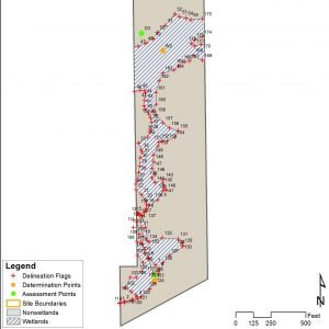
- Mapping the site by overlaying the field-collected GPS points on a base map and using those points to draw areas for the wetland and nonwetland site components.
- Calculating wetland and nonwetland acreages for the site.
- Describing the results of the field study in a report, set of maps and field data forms.
- Optional but typical: Submittal of the report to the US Army Corps of Engineers (USACE) for verification and a formal finding of jurisdiction under the Clean Water Act, called a ”Jurisdictional Determination’ or JD for short.
Wetland Delineation Process
Step 1: Wetland Determination
First, we have to establish if jurisdictional wetlands are present on the site, parcel or area of land being studied. In order for an area to be classified as a wetland, it must have three characteristics:
- Presence of wetland hydrology. Field indicators of hydrology, including depth to the water table, are observed, measured and recorded. These vary by region and typically include the presence of surface water, saturated soils, aquatic organisms, and a number of more technical indicators.
- Presence of hydric soils. A vertical soil profile is described, soil type, soil texture, soil color, and any hydric soil indicators are identified and recorded. Mapped soil survey data is used to pre-map soil types on the study site, but the field assessment of the soil profile is the final word in terms of actual site conditions and boundaries between hydric and nonhydric soil areas.
- Presence of hydrophytic vegetation (wetland plants). The dominant plants in the area are identified, measured to determine how much area each plant species occupies, and characterized according to their wetland indicator status.
These factors, or their absence are documented and a determination is made if the area is a wetland or nonwetland (the Corps’ term for upland). Once wetland and upland determination points have been established, we determine a boundary between them.
Step 2: Field Boundary Flagging
Next, the wetland boundary line is established and marked in the field with flagging tape or other survey markings. This is sometimes referred to as a wetland line or delineation line.

Step 3: Map Data Collection
Locations of key features are collected in the field using GPS. The wetland determination plot locations and wetland flag locations are collected in a differential or RTK GPS system. Typically, the positions are collected and processed to 1 meter accuracy or better. The accuracy requirements are usually set by the local United States Army Corps of Engineers District.
Step 4: Map Data Processing
The field data set is then processed and mapped in a Geographic Information System (GIS) or Computer Aided Drafting (CAD) software application. This may involve post-processing the GPS data to further refine accuracy. The points or other features collected by GPS are used to construct polygons or areas representing both wetlands and nonwetlands observed in the field.
The wetland boundaries are shown as a line on the map, along with the locations of the individual wetland flags that were placed in the field.
Step 5: Acreage Calculations
The delineated wetland area and upland area for the site are calculated using GIS software.
Step 6: Wetland Delineation Report
A report is compiled describing the results of the wetland determination, the location of the wetland boundary line, and the areas of wetlands and nonwetlands within the study site. Detailed documentation of the determination factors are included, detailing field indicators of hydrology, soil conditions, and wetland vegetation and wetland plant communities.
Step 7: Jurisdictional Determination
The final step is to have the delineation verified by the US Army Corps of Engineers. USACE reviews the report, verifies the methods are compliant with the delineation manual, performs a field check of the wetland flags, and either issues a jurisdictional determination or requests changes be made to the map prior to issuance of the JD.
Other ecological studies and permitting services are often combined with wetland delineations, particularly when the delineation is in support of a permit.
Associated Studies and Regulatory Actions
A wetland delineation is a foundational study for a number of regulatory reviews, including permitting processes involving:
- Clean Water Act Section 404 permits, including Nationwide Permits, Individual Permits and General Permits
- National Environmental Policy Act (NEPA) reviews that are part of a broad suite of Federal actions, including direct Federal projects and Federally funded projects. A wetland delineation is typically part of the Biological Assessment performed under a NEPA Environmental Assessment or Environmental Impact Statement.
Presence of wetlands on a site or proposed impacts to areas within mapped wetland boundaries typically are associated with additional studies, including:
- Threatened & Endangered Species Surveys
- Wetland Function Assessments, Ecological Function Assessments or Wetland Assessments
- Project Alternatives Analysis (typically part of the NEPA process)
- Wetland Mitigation Plans
Requirements vary depending on the proposed project type, the quantity of wetlands to be impacted, presence of any critical natural resources, the wetland types to be impacted, and individual State or Local regulatory agencies and their requirements. The permitting process required for the proposed project also may affect the studies and documentation required on the site.
Wetland Delineation Expertise
Qualifications & Experience
Good wetland delineators have a combination of field expertise, report writing and mapping expertise. A comprehensive understanding of natural resources, including water resources, vegetation, soils, sampling techniques, software and field assessment methods are all necessary for a competent wetland delineator. The most common professional qualification for wetlands professionals is the Professional Wetland Scientist (PWS) certification, issued by the Society of Wetland Scientists.
Wetland Experts at Cypress
Cypress has extensive experience with wetland delineations and jurisdictional determinations in US Army Corps of Engineers Districts throughout the United States. Our staff have performed hundreds of wetland delineations and wetland mapping studies up to 110,000 acres in size for parcel-based projects and hundreds of miles in length for linear projects, including projects for real estate developers, railways, transportation departments, port authorities, State/ Federal/ municipal governments, individual homeowners, other civil engineering firms, construction firms and nonprofit organizations.
Frequently Asked Questions
Q: Can I do this myself?
A: Not really. The Army Corps of Engineers has to accept the delineation as being credible and performed by a competent professional. The agency review team will likely not review your submittal. In some cases, they will go onsite and do the delineation themselves, but this has become increasingly uncommon since the 1990s and is almost unheard-of currently.
Q: I found the National Wetlands Inventory maps online. Will this serve in lieu of a wetland delineation?
A: Unfortunately (or fortunately, depending on how mis-mapped the NWI data is for your site) the National Wetlands Inventory is not intended to be site-scale mapping. It’s a study performed to estimate how many millions of square miles of wetlands are present in the USA. Although the errors average out in the final analysis, the maps are wildly inaccurate at the scale of most sites. For sites over a few hundred acres, the NWI is an OK starting point, but for smaller sites it can be very misleading.
Q: How much does a wetland delineation cost?
A: It varies. The big variables are: site size, walkability, complexity of the boundary line, and where you are in the USA. Although there are several factors in pricing, it is not difficult or time consuming to estimate budget for a wetland delineation. We typically have pricing completed and proposals issued in less than a day after a brief email or phone conversation.
Representative Wetland Delineation Projects
Texas Flat Mitigation Bank: 1985-acre wetland delineation (also endangered species survey, wetland function assessments, stream assessments, permitting, restoration planning)
Private Client: 200-mile linear delineation for utility corridor Mobile, AL to Jackson, MS (also endangered species survey, stream characterization, environmental assessment, permitting)
Turtleskin Creek Mitigation Bank: 2740-acre wetland delineation (also endangered species survey, wetland function assessments, stream assessments, permitting, restoration planning)
Representative Delineation Projects
Texas Flat Mitigation Bank: 1985-acre wetland delineation (also endangered species survey, wetland function assessments, stream assessments, permitting, restoration planning)
Private Client: 200-mile linear delineation for utility corridor Mobile, AL to Jackson, MS (also endangered species survey, stream characterization, environmental assessment, permitting)
Turtleskin Creek Mitigation Bank: 2740-acre wetland delineation (also endangered species survey, wetland function assessments, stream assessments, permitting, restoration planning)