Most people have seen the crew on the side of the road with tripods and yellow vests, glanced at them, and moved on. What they’re doing is more consequential than it looks. Land surveying is what happens before anything gets built. It’s how we establish where property lines actually are, what the ground looks like in three dimensions, and whether a site is physically suitable for what someone wants to put on it.
Get it wrong, and the consequences range from expensive to catastrophic: structures built on the wrong parcel, drainage systems that flow in the wrong direction, legal disputes over boundary lines that looked obvious until they weren’t.
This guide covers the core concepts, the methods used in practice, and what actually makes a survey reliable.
What Is Land Surveying? Core Concepts Explained
What is land surveying? At its most basic, it’s determining the precise positions of points on the earth’s surface – their distances from each other, their elevations, and the angles between them. Those points define everything from property boundaries to the exact location of a building foundation.
The discipline sits at the intersection of geometry, physics, and law. A boundary line isn’t just a physical line on the ground – it’s a legal fact. When a surveyor establishes one, they’re creating a record that can be used in court.
There are three main areas in basic land surveying:
- Boundary surveying defines the limits of a parcel – where one owner’s land ends and another’s begins. This is the type most homeowners encounter.
- Topographic mapping records the shape of the land: the hills, valleys, slopes, and drainage features. This data tells engineers what they’re working with before they start designing.
- Site planning takes topographic and boundary data and uses it to figure out where structures can physically and legally be placed.
Accuracy in all three areas is non-negotiable. A few inches off on a boundary survey can put a building on the wrong property. A slightly misread slope can send stormwater the wrong way and into a foundation. There’s no wiggle room.
Types of Land Surveying Methods
The tools have changed dramatically over time. The goal hasn’t. Early land surveying used chains and measuring tapes for distance measurements, and manual instruments called theodolites for angle measurements. These methods were slow, labor-intensive, and subject to accumulated error over long distances. But they established the geometric principles that still underlie everything done today.
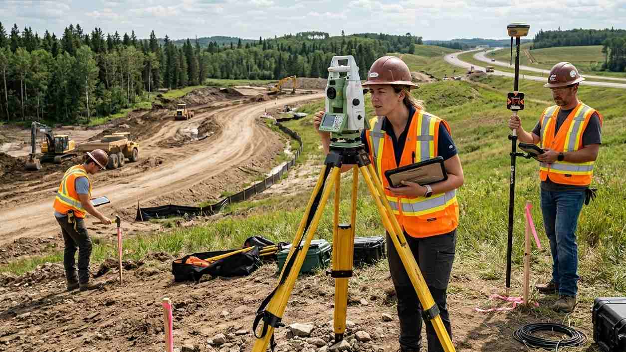
Modern sites use total stations as the standard instrument. A total station measures both angles and distances electronically, stores the data internally, and can be set up over a known point to tie measurements into a broader coordinate system. More recently, robotic total stations allow a single person to operate what previously required a two-person crew – the instrument tracks a prism automatically as the surveyor moves around the site.
GPS and GNSS have changed how control networks get established. Instead of chaining distances from a benchmark, surveyors can receive satellite signals and establish precise coordinates directly. For open terrain, this is faster than any ground method.
Drone mapping has added another layer – aerial coverage of large areas that would take days to walk. Drones capture thousands of overlapping photos that are processed into 3D terrain models and orthomosaics.
Dense tree canopy blocks satellite signals. Drones can’t find an iron pin buried six inches underground. Complex urban environments have too many obstructions for reliable GPS. Experienced surveyors choose methods based on terrain, required accuracy, and what the data will be used for.
Field Surveying: Step-by-Step Practices
Field surveying doesn’t start when the crew arrives on site. It starts in the office.
Before anyone picks up a tripod, the team researches historical records, land titles, and previous surveys of the area. Understanding what was recorded before tells you what to look for – and what might be wrong with earlier work.
On site, the crew does reconnaissance first: walking the property to locate existing monuments, iron pins, and physical features that mark boundaries. Finding these before setting up equipment saves hours of confusion later.
Equipment setup is where small mistakes compound. The instrument must be precisely leveled to a known point. A tripod that’s slightly off, a plumb bob that’s swinging in the wind – these introduce errors before a single measurement is taken.
Measurements proceed from a known control point: distances, angles, and elevations are recorded systematically as the crew moves through the site. Every feature gets logged – trees, curbs, utility covers, drainage structures. The measurement data is meaningless without the context around it.
Good field surveying uses a closed-loop check. The crew ends their measurements back at the starting point. If the final calculation matches the starting coordinates within acceptable tolerance, the work is solid. If it doesn’t, something went wrong – equipment bumped, measurement misread, a point incorrectly identified – and the team finds it before leaving the field rather than after.
Weather, traffic, and terrain all work against you during field work. None of that changes the standard.
Best Practices for Accurate Land Surveys
Accurate land surveying is a product of consistent habits, not just good equipment.
- Calibrate regularly. An expensive instrument that’s out of adjustment produces garbage data. Equipment checks should happen at the start of every field day, not whenever someone remembers.
- Follow the same procedures every time. Inconsistency is how errors slip in. When everyone on the crew does the same steps in the same order, mistakes are easier to catch, and the data is easier to verify.
- Keep detailed field notes. Even on projects where everything is recorded digitally, hand-written notes and sketches of the site provide context that the instrument data doesn’t capture. When a discrepancy shows up in the office, those notes explain it.
- Double-check in the office. All data should be reviewed by a second person before it is included in a deliverable. Typos and data-entry errors are real, and they’re easy to miss if only one person handles the numbers from field to final product.
- Communicate on-site. Surveying 101, the basics that apply to every job, includes keeping the crew coordinated. A team that’s out of sync misses measurements, misidentifies points, and creates more rework than the project can absorb. Clear, direct communication between crew members is as important as the instruments they’re using.
Surveying Tools and Technology Innovations
Surveying 101 covers the fundamentals. The field has moved well past that in terms of available tools. Robotic total stations let one person do what used to take two or three. The instrument tracks the surveyor’s prism automatically, taking measurements as they move. In open areas, a single operator can cover ground that would’ve taken a full crew significantly longer.
3D laser scanners capture millions of data points per second. They’re used for detailed as-built documentation of existing structures, tunnels, and complex mechanical installations. The output is a point cloud – a dense, three-dimensional representation of every surface in the scanner’s range. Engineers can take measurements from the point cloud rather than going back to the field.
GIS and CAD software process raw field data into deliverable products, including boundary plats, topographic maps, construction stakeout files, and 3D terrain models. Processing has become fast enough that preliminary results can be ready the same day as field collection.
The combination of aerial and ground methods is where most projects now land. A drone maps the broad area and establishes topography quickly. Ground surveying crews locate the specific points – property corners, utility features, construction benchmarks – that aerial methods can’t find. Neither approach alone covers everything.
Applications of Land Surveying in Real Projects
Land surveying touches almost every type of construction and infrastructure project. In commercial development, surveys confirm that a building footprint fits within the property boundaries and meets setback requirements before construction starts. In road and highway work, surveys ensure that two sections of pavement being built from opposite directions actually meet in the middle. In utility work, surveys map existing buried infrastructure so excavation crews know where not to dig.
The financial case for accurate surveys is simple: finding a problem before construction is inexpensive. Finding it after concrete is poured is not.
Field surveying also closes out projects, not just opens them. As-built surveys document what was actually constructed rather than what was designed. They verify that a foundation is where the plans said it should be, that a utility line was installed at the correct depth, and that a retaining wall was built to spec. These records matter for permitting, liability, and future work on the same property.
From property transactions to dam construction, the surveyor’s data serves as the baseline for everything else.
Cypress Engineering provides land surveying and ground surveying services for infrastructure, development, and engineering projects. Get in touch to discuss your project requirements.